DALLAS — Have you ever heard WFAA meteorologists talk about "the cap?"
Maybe you've lived in North Texas for some time, but never understood what they are talking about. Or perhaps you are new to North Texas, and still remain completely confused by this term.
Either way, let's talk about "the cap" and what it means for North Texas weather!
What is the cap?
The cap is a warm layer of air in the atmosphere above our heads. Usually, this layer of air is around 2,000 to 5,000 feet up in the atmosphere.
The reason we call it a "cap" is because this layer of warm air acts like a lid preventing storms from being able to form.

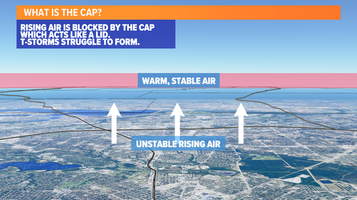
Think of it like a pot of boiling water with a lid on top. When the lid is on, hardly any steam can make it out of the pot. But when you remove the lid, all that built-up steam rises very quickly out of the pot.
So when a cap is in place, thunderstorms have a hard time forming -- because that cap or lid is keeping any air from rising and, thus, any thunderstorms from forming.
Where does the cap come from?
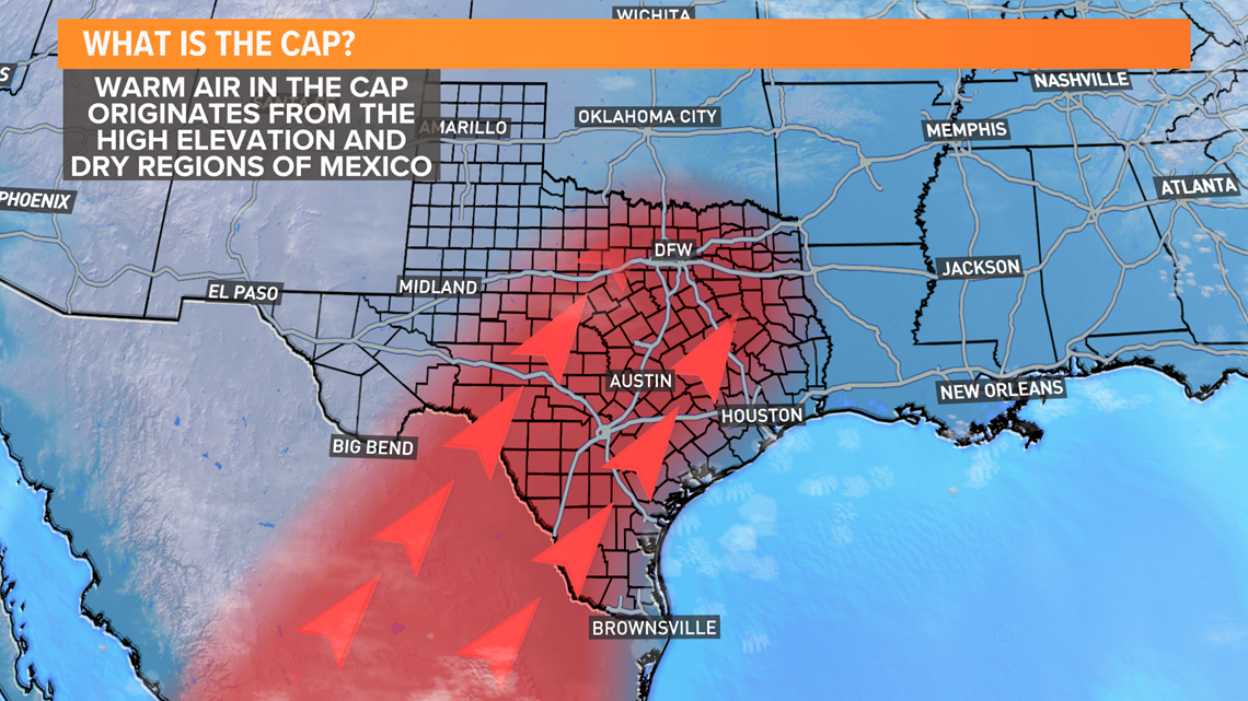
The cap is a unique feature that's especially common in Texas and Oklahoma -- but it can be found in other parts of the country that are prone to severe weather, too.
The cap is formed due to the higher elevations of Mexico to the southwest of Texas becoming warm and fairly dry this time of year. When the wind in the layer of the atmosphere above the surface (2,000 to 5,000 feet) comes from the southwest, this transports that warm and dry air into parts of Texas and North Texas.
That warm and dry air from Mexico then causes the cap to form above our heads.

What happens when the cap breaks?
Again, keep in mind that the cap is like a lid on a pot of boiling water.
If the cap is not there, storms can freely form, although it is hard for them to become severe. Days that don't feature a cap are usually days that feature widespread on-and-off showers and storms, but not much in the way of severe storms. Are severe storms possible in these cases? Sure! But they are not as common.
Think of how when a lid is not on the pot, and steam just keeps rising over and over, but stays pretty constant in its intensity.
Now, think about when you've had the lid on the pot and then you quickly remove it. All that steam suddenly bursts forth rapidly out of the pot.
That is very similar to what happens when the cap breaks here in North Texas.
In these instances, when warm, unstable air underneath the cap breaks through the cap, thunderstorms form very rapidly in the atmosphere and can quickly become severe. Energy has been brewing underneath the cap for some time, so when it breaks, thunderstorms can become quite strong -- and very quickly at that.
These cases are when we usually see the most intense storms we can get here in North Texas -- storms with very large hail, damaging winds and even tornadoes.
Does the cap always break?
Absolutely not!
This is a good thing, too. It prevents North Texas from seeing even more severe storms than we already do.
If the cap is very strong, sometimes it takes temperatures well over 100 degrees at the surface to break it. Thankfully, temps like this are not very common during the springtime. And, even during the summer when temps are that warm, the air can be too dry for thunderstorms to form like this.
It makes forecasting the weather difficult! Some days we have a chance for thunderstorms to form, but the cap never breaks, and all that happens is a warm and dry afternoon.
The strength of the cap can be hard to predict, and our computer models struggle with the strength of the cap sometimes.
One of the reasons why this is difficult is because a 1- to 3-degree difference in temperature is all it can take to determine if storms form or not.
You'll hear WFAA meteorologists talk about the cap a good amount throughout the year, so hopefully this article provides you a better understanding of what they're talking about.
And, now, when they say there is a chance for storms -- but then no storms form, you can take it easy on them -- because, again, the cap can be hard to predict.
Remember to download the WFAA app to check out our dozens of local radars near you, to get weather alerts and to see the latest forecast, cameras and current weather conditions around North Texas.