DALLAS — As we say goodbye to 2023, let us look back at the weather we saw during the year.
Everyone will remember the heat. It was the third hottest summer on record, but more on that later.
Quick Facts
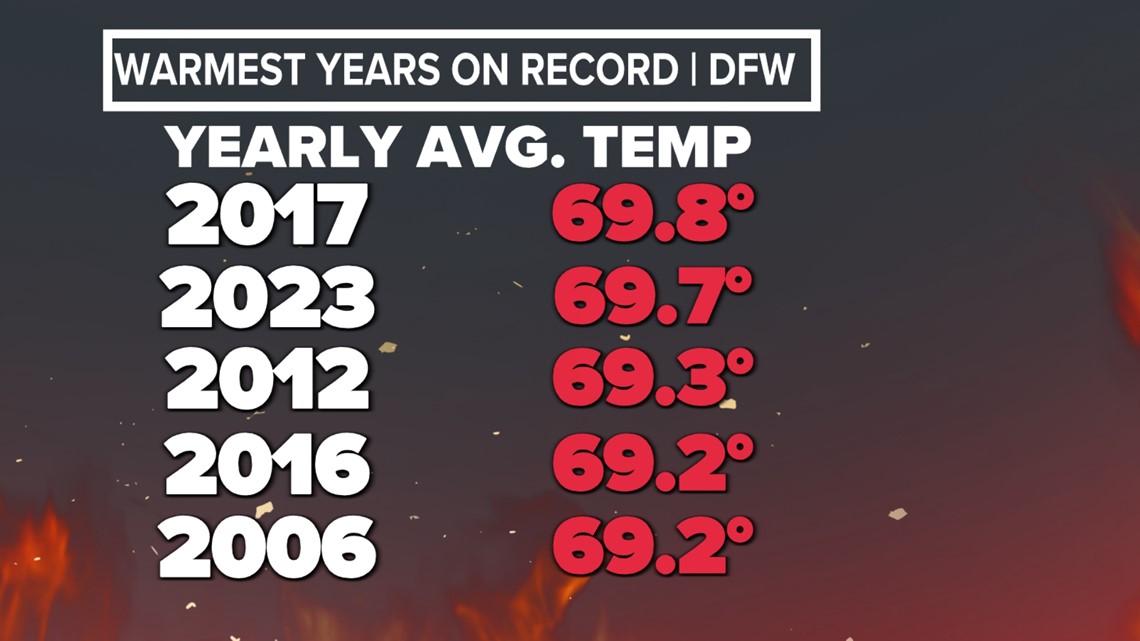
- Our average temperature for the year is 69.7 F, which is the 2nd warmest year on record. Just behind 2017 by just 0.1 F.
- Rainfall this year totaled 29.31 inches, which is below the normal yearly rainfall of 37.01 inches.
- The coldest temp of the year was 25 F back on January 31. That ties 2020, 1952, and 1941 for the "warmest" low temp for an entire year on record.
- The hottest temp of the year was 110 F, which happened three times! July 25th and 26th, as well as September 8th. This was the first year since 2011 that the temperature has climbed that high.
- Officially, the year ended up with 1.3 inches of snowfall. All of which happened on January 31, during our most significant winter weather event of the year.

General pattern
After three years in a row of La Niña conditions, El Niño developed around the beginning of summer. El Niño has continued to strengthen, and we are ending the year under the influence of a strong El Niño.
Even though most of the summer was technically in El Niño conditions, the quick development of El Niño likely did not allow North Texas to reap the benefits of a typical El Niño summer, which normally causes cooler than normal summer temps.
Third hottest summer on record
The heat was a bit delayed this summer. But when it arrived, it arrived in full force. Most of July, all of August, and the first half of September were just plain miserable.
The summer ended up being the third hottest on record. Only the summers of 1980 (second) and 2011 (first) were hotter. Another reason it felt like a miserable summer was how late in the calendar year DFW was still recording triple digits. DFW recorded the last triple digit heat day on Sept. 24 which is over a month later than 2022.
Here are some of the notable heat records from this summer:
- 55 days at or above 100 F...fourth most on record behind 2011( 71 days), 1980 (69 days), and 1998 (56 days)
- 26 days at or above 105 F...second most on record behind 1980 (28 days)
- 3 days at or above 110 F...second most on record behind 1980 (5 days)
- 21 consecutive days (July 24 - Aug. 13) at or above 100 F...tied for 6th most on record. The most on record is 42 consecutive triple-digit days during the summer of 1980.
- 47 days with a morning low at or above 80 F..the second most on record behind 2011 (55 days)
- The second warmest August on record with an average temp of 92.9 F.
A Dry Summer
Heat like we had this summer typically goes hand in hand with drought conditions. And that's exactly what we saw. Drought only got worse through the summer, thanks to the hot and dry conditions.
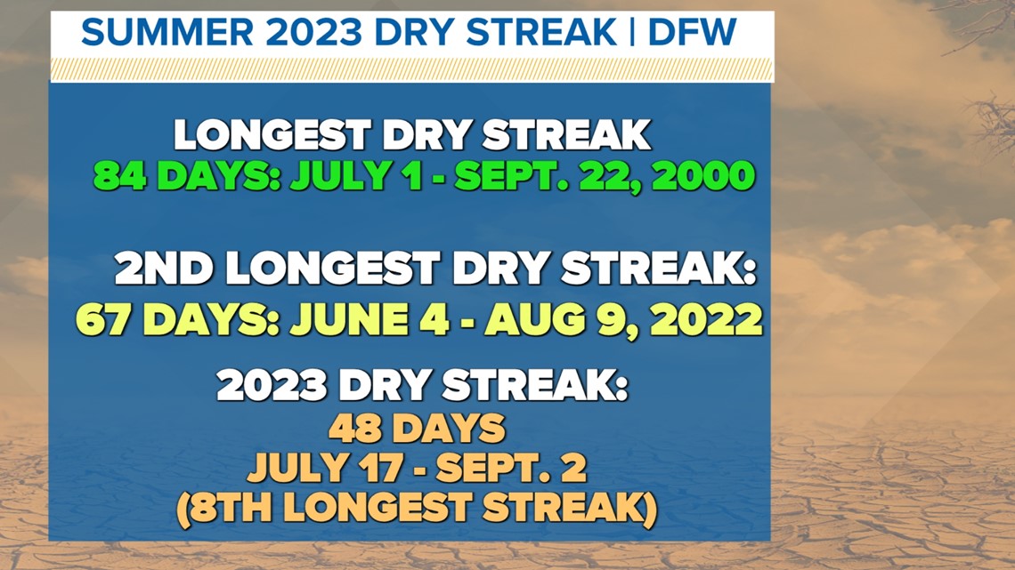
DFW went 48 days in a row without measurable rain from July 17 to September 2, which is the eigthh longest streak on record. The longest streak was 84 days in 2000.

DFW only managed 1.25 inches of rainfall this summer, which is the fourth driest summer on record.
And August did not receive any measurable rainfall. In over 120 years of records, that has happened seven other times during the month of August.
Record rain
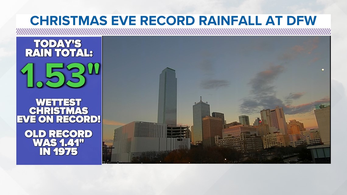
The summer was hot and dry, but a shift happened late in the year. This was visible with a record amount of rainfall on Christmas Eve! December 24th, 2023, picked up 1.53 inches of rain, making it the wettest Christmas Eve since records started.

Late January - Early February sleet, ice, and snow
The only significant winter weather event of the year was a round of freezing temps, sleet, freezing rain, and snow that occurred from January 30 to February 1.
DFW spent 88 hours in a row below freezing and picked up 1.3 inches of sleet/snow fell on January 31, which was a record for that day.
Of course roads where slick and hazardous during that time as sleet, freezing rain, and snow created ice covered roadways. The ice also severe impacted our local airports with over 4,000 cancellations between DFW Airport and Dallas Love Field combined.
Hail and tornadoes
Like every year, North Texas dealt with severe weather. This year, North Texas reported a total of eight tornadoes. The average number of tornadoes for North and Central Texas over the last 10 years in 27 per year, so that puts us well below the average.

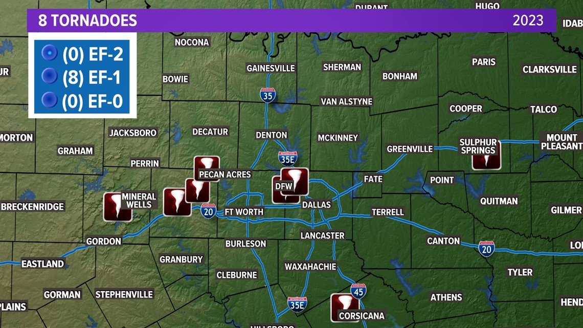
Out of the eight tornadoes in North Texas, there were two in Dallas County, two in Parker County, one in Wise County, one in Palo Pinto County, one in Hopkins County and one in Navarro County.
This year also recorded a new record for the largest hailstone size in North Texas. About 12 miles north of Denton, a hailstone from June 15 at 5.9 inches in diameter.
Multiple hail storms crossed parts of the Dallas-Fort Worth area as well during the spring months causing damage to homes and vehicles, but that is what we expect that time of year.
What's in store for 2024?
Hopefully not as hot of a summer!
Statistically speaking, that's unlikely.
The year will start off with a strong El Niño, but it looks like El Niño will weaken to neutral conditions by the summer, with possibly even La Niña showing up again by the end of the year.
It is North Texas, so we'll probably be in store for triple digits, hail, tornadoes, flooding, cold, and wintry weather at some point during the year.