

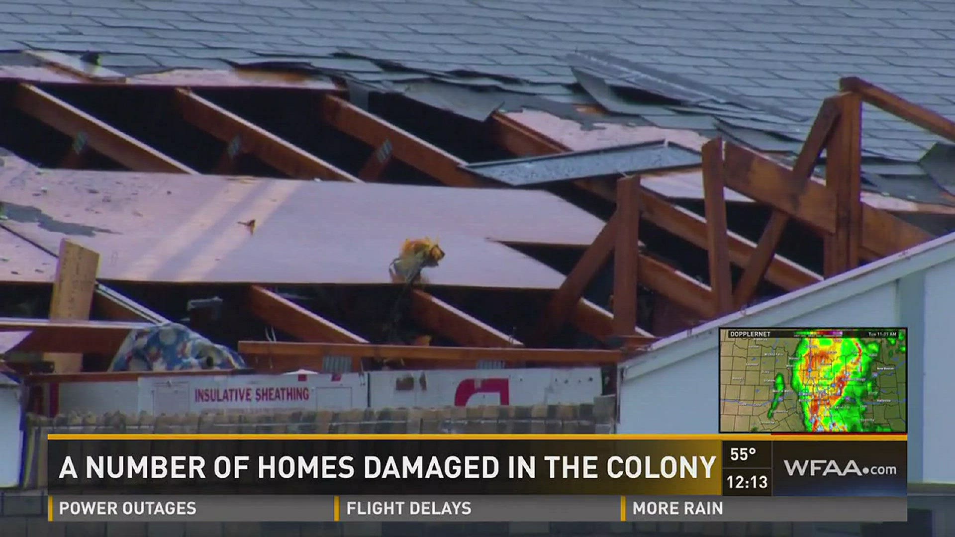
Update: The number of confirmed tornadoes has been increased to five. In addition to three EF-1 tornadoes Monday night into Tuesday morning, two EF-0 tornadoes have been confirmed in The Colony and Benbrook.
Two EF-1 tornadoes were confirmed in North Texas as a line of strong severe thunderstorms moved through the metro area between 6 and 10 a.m. Tuesday.
A tornado that hit Cool, TX Monday night was also rated an EF-1.
Damaging winds were accompanied by torrential rain that produced flash flooding for some areas Tuesday.
Thunderstorm activity will continue through late Tuesday afternoon. Another round of storms will arrive after midnight, with widespread heavy rain and flash flooding being the main concern.
Severe damage was reported in areas of Cool and Millsap after an EF-1 tornado hit the area just after 6 p.m. Monday in Parker County. Stephenville and Tolar also saw tornadoes rated as EF-1 by the National Weather Service.
5:56p American Red Cross opens a shelter for residents affected by the tornado that damaged an apartment complex in Stephenville. The shelter is located at:
Stephenville Senior Center
164 College Street
Stephenville Tx
The Red Cross says 16 units were destroyed and the building was without power.
5:55p Images taken in Tolar, where an EF-1 hurt at least two people and left behind massive destruction.
5:19p Third EF-1 tornado confirmed in North Texas. EF-1 winds of 85-95 mph winds were reported in Cool, Stephenville and Tolar, TX.
Tolar #tornado has been given a rating of EF-1. Top winds 85-95 mph #dfwwx
— NWS Fort Worth (@NWSFortWorth) March 8, 2016
3:25p FM 407 in Northlake will remain closed due to high water, according to Northlake PD.
3:13p Second EF-1 tornado confirmed by NWS Fort Worth
Lots of straight line wind damage in Stephenville this morning. Also, narrow EF-1 #tornado damage embedded. #dfwwx pic.twitter.com/TwmhRbm0tg
— NWS Fort Worth (@NWSFortWorth) March 8, 2016
2:46p Fort Worth will close boat ramps at Lake Worth starting at 5 p.m.
2:30p Denton driver rescued from flood waters.
1:45p National Weather Service Fort Worth rules the tornado in Cool, TX Monday night was consistent with EF-1 winds.
Damage from #tornado near Cool, Texas from last evening. Damage consistent with EF-1 winds. #dfwwx #txwx pic.twitter.com/h03dcSwtq5
— NWS Fort Worth (@NWSFortWorth) March 8, 2016
12:57p Tornado Warning issued for Southeastern Van Zandt County until 1:30 p.m.
12:37p Tornado Warning issued for Henderson County in Central Texas until 1 p.m.
12:22p Damage update: 12 homes hit in The Colony. No injuries reported. Sebastian Robertson reports from the scene.
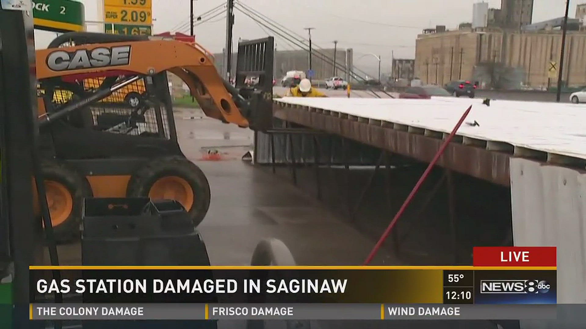
12:20p Gas station in Saginaw is damaged. Jenny Doren reports from the scene.
12:15p Take a look back at the storm clouds moving in with time-lapse video from our tower cameras over downtown Dallas.
#Timelapse: Storm clouds roll into downtown Dallas. #WFAAWeather
— WFAA-TV (@wfaachannel8) March 8, 2016
Weather updates: https://t.co/cb23k13gHnhttps://t.co/GvLC4OC0yU
#Timelapse: Storms moving into Dallas, from our @KlydeWarrenPark camera. #WFAAWeather
— WFAA-TV (@wfaachannel8) March 8, 2016
MORE: https://t.co/cb23k13gHnhttps://t.co/Zv6fFTZfn2
11:50a Severe threat has diminished. All warnings have expired. Expect rain, thunder, lightning through the lunchtime hour.
11:39a Several roads in Denton have been closed due to high water:
- Northbound I-35E frontage road from McCormick to Underwood Streets.
- Underwood Street as it approaches the northbound I-35E frontage road.S
- Southbound I-35E frontage road from Bonnie Brae Street to North Texas Boulevard.
- If you want to access the Denia neighborhood, you should exit at McCormick and travel west.
- 35Express
11:33a Garland police say a driver was injured after flying debris hit a van in the 2600 block of Industrial Lane. The driver was taken to local hospital in critical condition.
Strong winds cause damage to buildings and vehicles in the 2600 block of Industrial Ln. One person injured. pic.twitter.com/WRloCKz83k
— Garland Police PIO (@GarlandPD) March 8, 2016
11:31a TCC Northwest says evening classes will still take place starting at 5 p.m. today.
10:55a NB Loop 12 at 114 is closed temporarily due to high water - Irving PD
10:35a Church damaged, four schools without power in Lake Worth; damage to Tarrant County Community College Northwest Campus (classes canceled until 5 but no injuries reported); Damage reported at Lake Benbrook's marina; Traffic lights down in Saginaw. -- Mark Flake with Tarrant County Sheriff's Office
10:30a Classes continue at Eagle Mountain Saginaw ISD schools after tornado warning was lifted. The district took “precautionary measures by placing all campuses in duck and cover” Tuesday morning.
Power and phone lines were restored at all of the district’s school except CTHS and the Hollenstein CTC. Students would remain at school.
-- Info from EMS ISD
Video of possible tornado in Tolar sent to us by Jared Morris. #WFAAWeather
— WFAA-TV (@wfaachannel8) March 8, 2016
LIVE COVERAGE: https://t.co/CwTuQW6n1Yhttps://t.co/lTetLXeyK6
10a Heavy rain and frequent lightning continues south of DFW. Hillsboro and Waco can also expect high winds.
9:24a Tornado Watch continues south of DFW until 1 p.m. So far 60 mph are the main threat, but we will continue to monitor for rotations.
9:20a Highway 114's westbound lanes shut down in Grapevine at Texan Trail due to overturned 18-wheeler.

9:13a A jack-knifed 18-wheeler at I-30 in Fort Worth is blocking traffic. One lane is getting through. The ramp from southbound West Loop 820 is closed.
Jackknifed 18 wheeler at I30. One lane getting thru. Ramp from SB West Loop 820 shutdown#DFWTraffic #dfwweather pic.twitter.com/rOqsWwqUgY
— Fort Worth Police (@fortworthpd) March 8, 2016
9:08a Stephenville PD says temporary shelters have been set up at the Rec Hall and Senior Citizen Center.
9:07a Severe Thunderstorm Warning for Collin County until 9:30 a.m.
9:06a The Denton School District confirms that six students and a bus driver were rescued Tuesday morning after their bus got stuck in water.
8:49a About 27 delays reported at DFW Airport after "Ground Stop" issued at 8:30.
- Check your flight's status here
8:41a Severe Thunderstorm Watch extended to 11 a.m. for Delta, Hopkins, Lamar and Rains Counties. -- NWS
8:37a Severe Thunderstorm Warning for Dallas County until 9:30 a.m.
@wfaachannel8 @wfaaweather at Greenville and Mockingbird pic.twitter.com/uxDgUNnFmM
— Ryan Miller (@rjmcougar) March 8, 2016
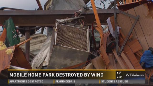
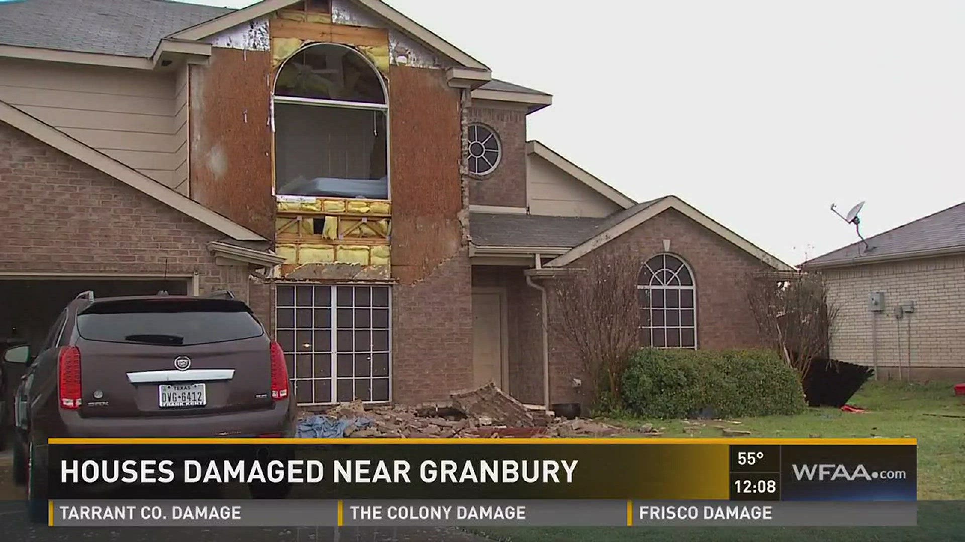
8:27a Hood County Sheriff's Office reports 60-70 mph winds. At least two injured at Jacks Trailer Park on Highway 377. In Hood County, 22 homes were damaged or destroyed. Pea-sized hail reported but no flash flooding. Damage also found in Cresson Area-Scenic Ridge and Meandering Estates.
Damage from reported tornado at Jack's Trailer Park between Granbury and Tolar. All accounted for, 2 to LGMC. pic.twitter.com/YbFx7WWM3U
— Hood County News (@HoodCountyNews) March 8, 2016
8:20a Downtown Fort Worth reporting 60 mph. - NWS Fort Worth
8:18a Tornado Warning expired for Dallas-Fort Worth area.
8:09a Damaging straight line winds moving into White Settlement. Winds of up to 65 mph.
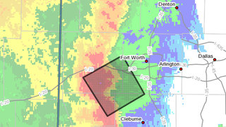
7:50a Tornado Warning issued for SW Tarrant, SE Parker, NW Johnson and NE Hood Counties until 8:15 a.m. - NWS
7:35a The Severe Thunderstorm Watch now includes most of the DFW counties until 11 am.

7:17a Severe Thunderstorm Warning for Erath, Hood, Palo Pinto, Parker and Somervell Counties until 8:15 a.m. Storm is moving northeast at 45 mph.
7:06a A Flash Flood Warning has been issued for Jack, Palo Pinto and Parker counties until 10 a.m.
This is what it looks like on 35 headed south toward Dallas. Pockets of heavy rain #wfaaweather @wfaachannel8 pic.twitter.com/NgcAWdh2wL
— Jenny Doren (@JennyDoren) March 8, 2016
Tuesday raining morning at 6:30am @wfaachannel8 @WFAAalexa @roncorning @dajamur @wfaaweather pic.twitter.com/RsfOISu571
— Felipa Loredo (@pipafrausto) March 8, 2016
6:19a Line of storms is moving northeast. Timing shows it hitting Weatherford at 7:11 a.m. and it'll be in Arlington after 8:30 a.m.

5:30a Severe T-storm warning for Stephens Co. until 6:15 a.m. 60 mph winds possible.
1:45a Severe weather threat has diminished overnight, but it continues Tuesday. Flash flooding will be the main concern Tuesday morning through midday. Severe storms will be possible during the afternoon/evening hours. - Meteorologist Steve McCauley

MONDAY
10:50p
UPDATED NUMBERS: 12 homes, 4 barns damaged near Cool, TX, in Parker County #wfaaweather pic.twitter.com/5NHGfiSASN
— Lauren Zakalik (@wfaalauren) March 8, 2016
9:41p
High winds in Whitesboro! EMs report wind damage 8:45pm @ SH377 & Spur 153.RV blown into car, 18-wheeler blown over: pic.twitter.com/n4nFDv5oSx
— WFAA-TV Weather (@wfaaweathertoo) March 8, 2016
9:32p Earlier in the evening, Nathan McMurray captured this video of a possible tornado taken about five miles north of Weatherford on FM 51:

8:55p
Incredibly, no injuries. But bone-shaking thunderstorms continue & are soaking what's left of homes #wfaaweather pic.twitter.com/FqPxYAAj6q
— Lauren Zakalik (@wfaalauren) March 8, 2016
8:26p Tank Battery fire five miles south of Myra in Cooke County. The fire was likely sparked by a lightning strike, says the EM office.
8:15p Dallas/Fort Worth International Airport is reporting gate hold and taxi delays between 31 to 45 minutes in length "and increasing." "Arrival traffic is experiencing airborne delays of 15 minutes or less."
8:13p There are reports of water rescues in Lone Camp in Palo Pinto.
8:05p Officer Rich with the North Richland Hills Police Department rescued this pig from a busy intersection at Boulevard 26 and 820 EBA.
Officer Rich saved this pig from the roadway. Yes, he 👮 is holding...a pig... We're ready for your jokes now... 🐷 pic.twitter.com/4yS26HEbjq
— NRH Police (@NRHPD) March 8, 2016
8p A total of seven homes are "destroyed" by storm, possibly by a tornado, on 180 east of Cool. - Reporter Lauren Zakalik

7:36p
EARLIER: Possible tornado near Millsap on storm that moved through Cool, TX. pic.twitter.com/NfNFRpX0yd
— Tornado Trackers (@tornadotrackers) March 8, 2016

7:16p
Wow. Parker co sheriff deputy just told us 180 is closed near Millsap bc "everything's in the streets... homes... a tornado." #wfaaweather
— Lauren Zakalik (@wfaalauren) March 8, 2016
7:05p
Two emergency vehicles scream by on 180 west of Weatherford. Rain & lightning turning heavy #wfaaweather pic.twitter.com/SCETsenEP5
— Lauren Zakalik (@wfaalauren) March 8, 2016
7p A swift water rescue has been reported on FM 4 just south of Crown Road, where a person is reported trapped in a vehicle and others in a trailer in Palo Pinto.
6:58p. Ambulance has transported one person from scene in Cool area. - Josh Stephen, WFAA photojournalist
6:57p Water rescues underway at FM 4, according the sheriff in Palo Pinto County.

6:50p A severe T-storm with torrential rainfall, pocket-change hail, and 60 mph winds is moving across southern Wise County and heading NE at 35 mph. Weak rotation is indicated just about seven miles north of Springtown, but no additional tornado touchdowns have been reported. But residents across Wise County, and in particular the area between Boyd and Paradise and eventually the city of Decatur, should be on the alert to the approach of this storm. - Meteorologist Steve McCauley
6:48p A Severe Thunderstorm Warning continues for Parker County until 7 p.m.
6:40p Tornado Warning in Parker County has expired.
A Flash Flood Warning has been issued for Palo Pinto and Parker Co. until 8:30PM. #wfaaweather pic.twitter.com/YfZZsjnUmJ
— WFAA-TV (@wfaachannel8) March 8, 2016
6:30p There are reports of near Cool in Parker County. There have been no reports of injuries or a confirmed tornado, but people have reported high winds. Several structures and some cars have been damaged.
1st Tornado Warning of the season just issued for rural NW Parker County til 6:45. No confirmed tornado #wfaaweather pic.twitter.com/uDqLulUod4
— Pete Delkus (@wfaaweather) March 8, 2016