DALLAS — We're currently tracking storms, possibly severe, in North Texas on Monday. Stick with WFAA for continued coverage throughout the day, including updates from Chief Meteorologist Pete Delkus at 5, 6, and 10.
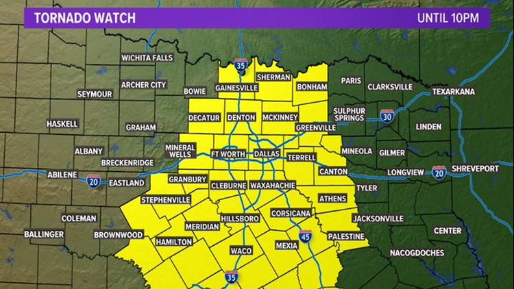
A tornado watch has been issued for most of North Texas, including the metroplex.


Latest updates from the WFAA weather team:
7:20 p.m.: New Severe Thunderstorm Warning for parts of Collin, Hunt, Grayson and Fannin Counties. Damaging wind gusts up to 60 MPH and quarter size hail.
7:00 p.m.: New Severe Thunderstorm Warnings for Ellis, Hill, Johnson, and Navarro Counties 60 MPH wind gusts and quarter size hail the concern.
6:55 p.m.: Tornado warning for Collin & Denton County has expired. There are currently NO TORNADO WARNINGS in North Texas.
5:58 p.m.: Metroplex Timeline: Severe thunderstorms are moving into the metroplex right now. Here's the timeline of when they'll arrive in your area. Keep on top of all warnings. Tornado potential remains elevated this evening
5:45 p.m.: TORNADO WARNING for TARRANT COUNTY. Northeast Tarrant County is in the path of this dangerous thunderstorm. You need to get into your safe space immediately.
5:14 p.m.: NEW Tornado Warning issued for Cooke County. Gainesville is in the path of this dangerous storm. Please seek shelter immediately.
5:05 p.m.: NEW Severe Thunderstorm Warning issued for Erath, Parker and Hood Counties. The main concern is a damaging wind threat with some hail possible too.
5:00 p.m.: A NEW Tornado Warning has been issued for Montague County. The center of rotation is near Nocona, just on the east side, and crossing HWY 82.
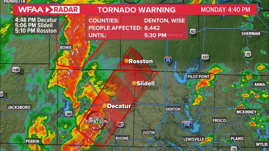
4:46 p.m.: NEW TORNADO WARNING for Wise and a small portion of Denton Counties. If you live in Decatur, seek shelter NOW.

4:20 p.m.: Tornado warning for Montague County. If you live in Bowie and Montague - seek shelter now! Storm has a history of producing debris and damage.
4:15 p.m.: Multiple reports of heavy debris near Jacksboro. This includes a roof collapse and reports of extensive damage at Jacksboro High School.
3:50 p.m.: New tornado warning has been issued for Jack County. This is a radar-confirmed tornado. If you are in this track, seek shelter immediately. This includes Jacksboro.
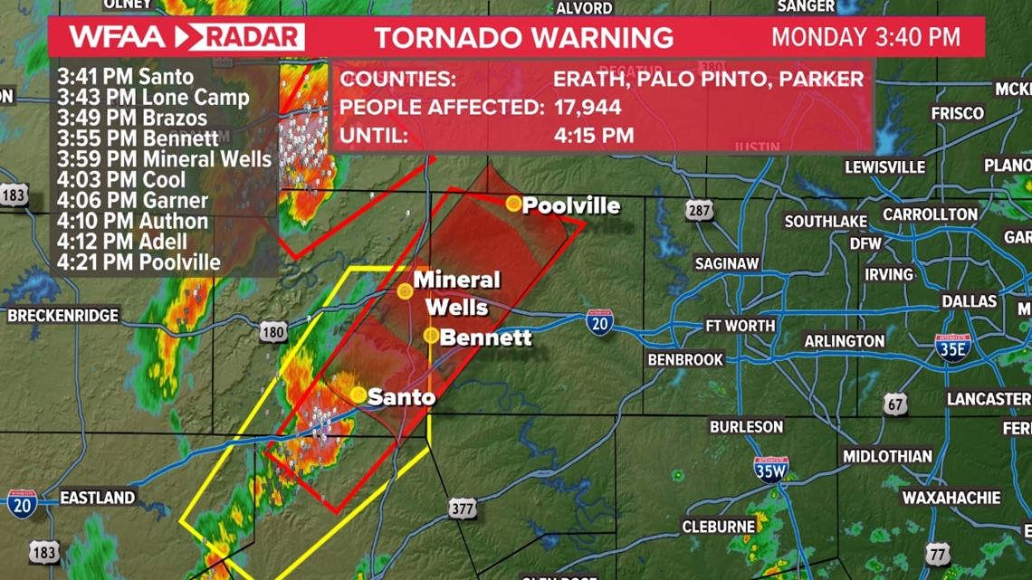
3:36 p.m.: New tornado warning for Erath, Palo Pinto, and Parker Counties. If you are in this warning area seek shelter now!

3:15 p.m.: Tornado Watch until 10 p.m. for much of North Texas.
3:10 p.m.: Tornado Warning for Jack, Palo Pinto, Stephens and Young counties until 3:30 pm. A storm capable of producing a tornado located near Possum Kingdom State Park moving NE at 50 mph. Take shelter.
2:20 p.m.: Our first warning of the day: A severe thunderstorm warning has been issued for Eastland and Stephens Counties. This storm could produce hail up to the size of quarters and 60 MPH winds.
Here's a look at the approximate timeline Monday:
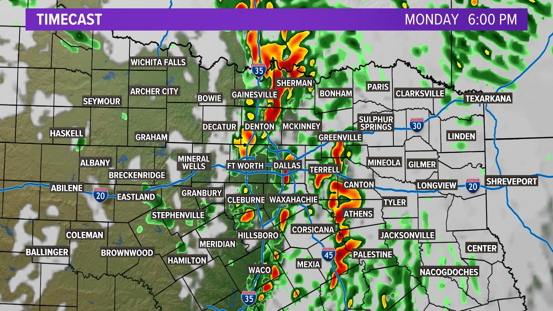
Live DFW Radar
Track the storms as they develop in North Texas:
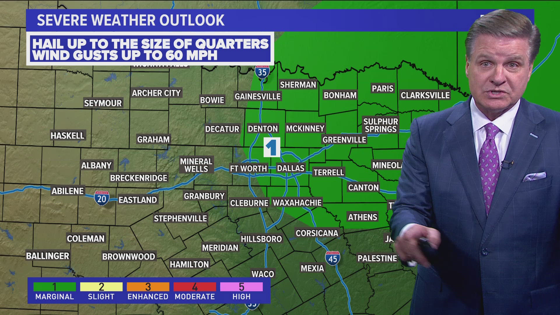
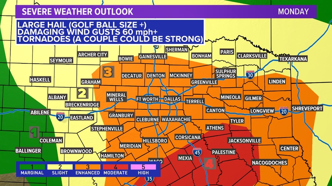
Storm threat risks
The severe weather threat has been expanded farther north to include the D/FW Metroplex in the Enhanced Risk (level 3). Quarter to golf ball size hail and larger, damaging winds and tornadoes will possible in this area.
A Moderate Risk (level 4 of 5) has been issued to include central and southeast Texas.

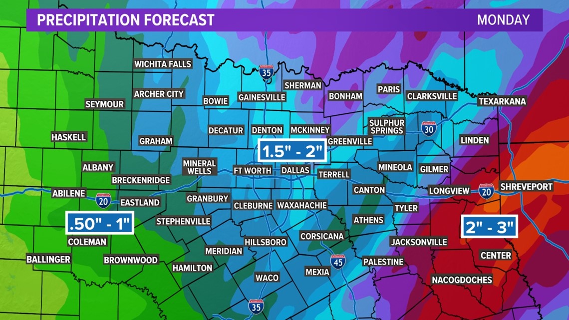
Locally heavy rain will be possible in some areas as well. Most of North Texas could see 1.5 inches to 2 inches of rain, with higher amounts to the east and northeast of our area. Areas east of the metroplex have a flood risk.
Here's a look at the Rainfall forecast:

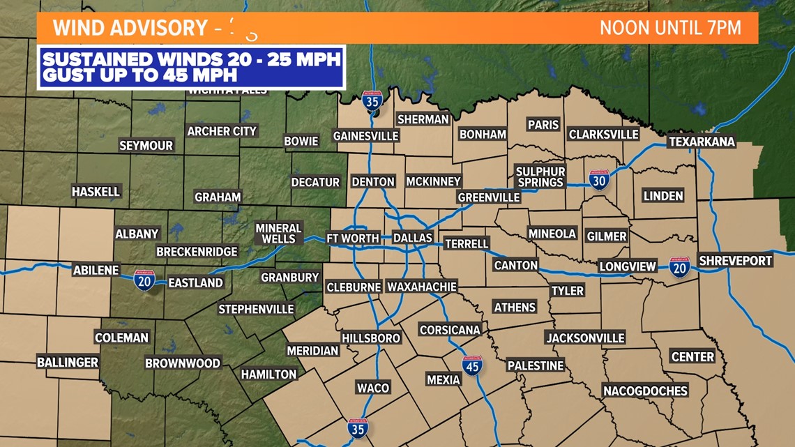
Outside of the thunderstorms, gusty southeast to south winds will continue into the early evening and a Wind Advisory remains in effect for most of North Texas and parts of areas west of Abilene.

The wet weather will stick around through Tuesday, though our severe weather chances will eventually taper off.
Moving forward, we'll warm into a nice stretch of spring weather, with temperatures in the 60s, 70s and eventually 80s by this weekend.
Keep checking back through the day for the latest updates!