

DALLAS — Thursday is expected to be an active weather day across North Texas, with severe thunderstorms and a potential for tornadoes.
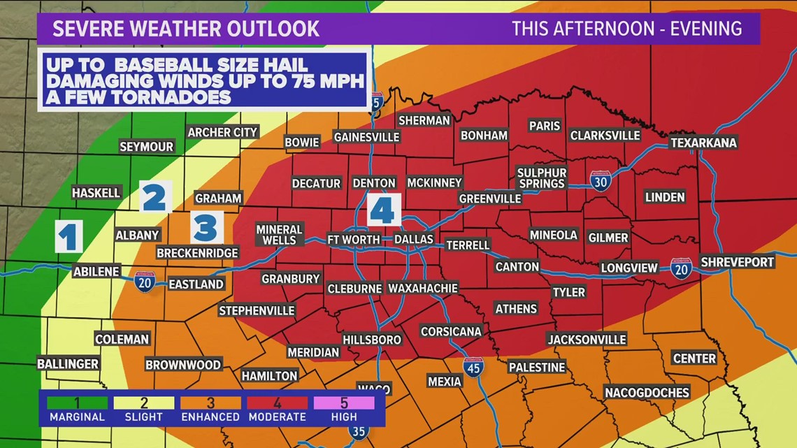
And that's indicative by the range of risk categories issued by the National Weather Service for North Texas, with far western areas of the region under a Category 1 "marginal" risk or Category 2 "slight" and Category 3 "enhanced" risks, and all of Dallas-Fort Worth under Category 4 "moderate" risk.
The Category 4 risk level was expanded to include all of DFW on Thursday morning, upgrading the severe potential for the Metroplex.
Here's the current outlook, as of just after 1 p.m. on Thursday:

But what does each risk category mean? And what can you expect for the one you're under?
Here's a rundown from the Storm Prediction Center (SPC):
What are the five risk categories?
In order of risk and severity, here are the five categories and what they mean, according to the SPC:
1. Marginal (Green): This initial level means isolated severe thunderstorms are possible. Storms would likely be limited in how long they last, how much area they cover and how intense they become.
2. Slight (Yellow): A slight risk means scattered severe storms are possible, though they'd likely be short-lived and not have widespread coverage over an area. While they might not be as persistent, these storms could still produce isolated intense conditions.
3. Enhanced (Orange): Under enhanced conditions, numerous severe storms are possible. This level is marked by more persistent and widespread storms, a few of which could be intense.
4. Moderate (Red): Jumping to a moderate risk level means more widespread severe storms are likely, and they could be long-lived and intense.
5. High (Pink): The highest risk category means widespread severe storms are expected to happen and they'll be long-lived, across a wide area and "particularly intense," according to the SPC's guidance.
Here's an explainer from meteorologist Mariel Ruiz last year:
Thursday Forecast
Better storm chances will be during the afternoon into evening as a cold front enters North Texas.
Storms will develop along that cold front likely somewhere west of the DFW area. Exactly where is still not completely certain, but likely between Abilene and Fort Worth.
Those storms will then form into a line and sweep across North Texas arriving in DFW anywhere from 4 p.m. to 7 p.m.
It is possible to see a few isolated strong to severe storms during the early afternoon time frame, before the main line of storms arrives.
Primary concern with that line of storms will be strong wind gusts (60-70mph) and large hail (quarter to golf ball size). With a line of storms, the tornado threat is certainly not zero, but it is lower than with individual supercell type storms. Within that line there could be a few brief spin-up tornadoes.
Storms will move east and out of North Texas through the late night hours with the area looking storm-free by midnight.