
DALLAS — You'll want to pay close attention to this storm. Turn on WFAA at 10 p.m. each night this week with Chief Meteorologist Pete Delkus. He's covered many a winter event, and will make sure you know what you need to each night.
EN ESPAÑOL: Tiempo invernal: cuando se espera el frío, hielo, aguanieve y posiblemente nieve por el Norte de Texas
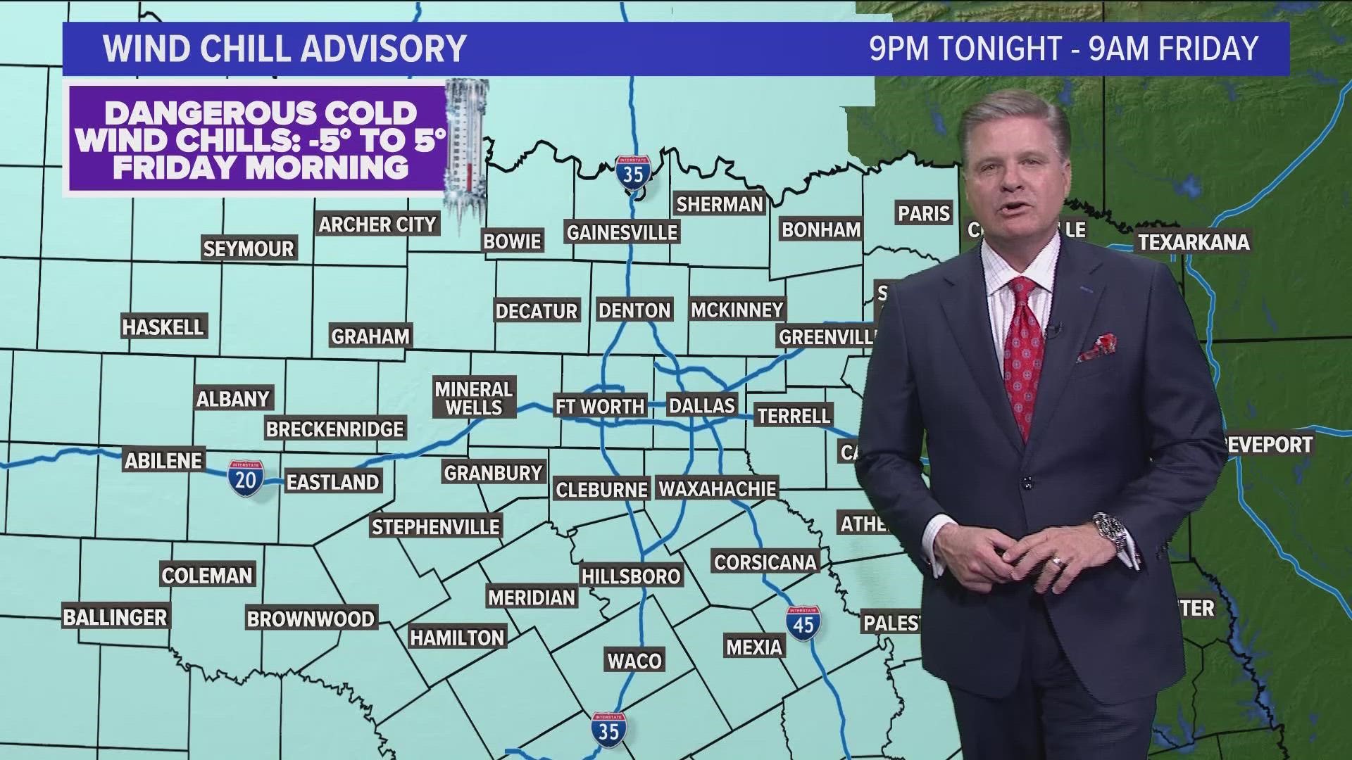
Winter storm warning
A Winter Storm Warning is in effect for all of North Texas. Accumulations of sleet, snow are ongoing in North Texas.
Travel will be difficult due to ice and snow Thursday and Friday. Ice accumulations and gusty winds on utility lines could cause power disruptions. Cold wind chills could result in hypothermia if precautions are not taken.


The Warning is set to expire at 6 p.m. tonight when all wintry weather should be done falling in North Texas, but cold temps and hazardous roads are possible into the weekend.
Watch Pete's extended forecast from Tuesday night:
Here's what to expect rest of the day:

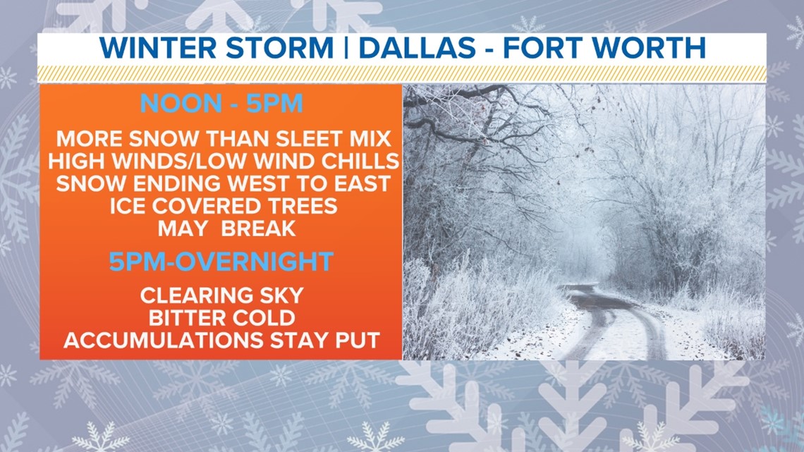
Timing
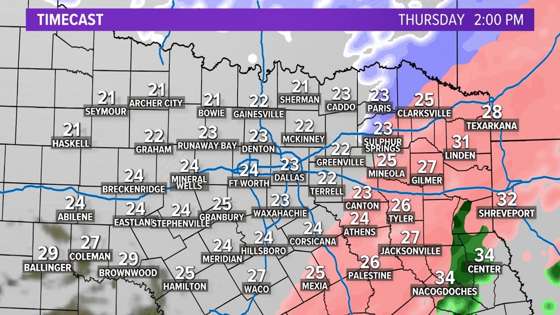
Temps have fallen well below freezing across D-FW and most of North Texas.
Freezing rain transitioned to mainly sleet mixed with snow during the late night hours. Sleet then continued to transition snow across D-FW and the western half of North Texas by Thursday morning. Snow is now ending from west to east through the early afternoon hours.

Accumulations or amounts
Remember, freezing rain, which will cause ice, accumulated first. Followed by accumulations of sleet and snow Thursday morning.
Ice accumulations northwest of the Metroplex were on the order of 1/10 to 1/4 inch with localized areas of 1/2 inch closer to the Red River. We still expect additional ice accumulations of 1/10-1/4 inch southeast of the Metroplex as temperatures fall into the upper 20s. Total snow and sleet accumulations will range from 3-4 inches across the northwest with much less across the southeast with 1-2 inches being most common elsewhere.
Areas that see the highest amounts of freezing rain will also be most susceptible to power outages.
For D-FW and the rest of North Texas, any sleet or snow accumulated on top of the freezing rain or ice.
Travel concerns
Then travel issues will continue all day on Thursday and Friday due to the very cold temperatures and little melting on Friday.
Since hardly any melting will occur, Friday morning will likely have big issues as well.
During the day Friday, actual temps (which are taken in the shade) may not warm above freezing, but it will also come with sunshine. Areas that see good sunshine should start to melt any ice or snow.
However, anything that does melt will re-freeze Friday night and lingering slick spots or travel issues are possible Saturday morning.
Thankfully, a good deal of melting will occur on Saturday with only a few slick spots likely by Sunday morning.
Temperatures
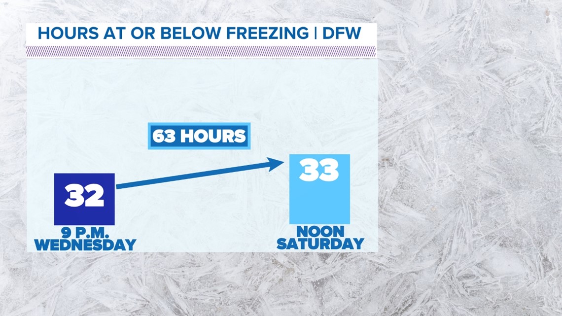
This does look to be the coldest air of the season so far. Temps fell below freezing sometime Wednesday evening (8 p.m. give or take) and won't warm up above freezing until Saturday around midday.

Lows look to be well down in the 20s Thursday morning, with lows in the teens Friday and Saturday morning.


None of these temps look to be record cold, but very cold nonetheless.
Power Outages
With the events of last year, this is likely on everyone's mind.
With any winter weather event, there is always the risk of power outages. Especially if ice is in the forecast.
Ice can accumulate and weigh down powerlines causing them to stop working. Or ice on tree branches can sag down onto powerlines as well. You can have the best electric grid in the world, but if powerlines are above ground, there will always be a threat for power outages.
We've seen that before. Events of February 2011 and December 2013 "Cobblestone Ice" come to mind.
What ends up happening with this event remains to be see, but we've seen winter storms have a strong impact on power and travel in North Texas.
Will this be like February 2021?
In short, no.
That was a once in a 30- to 50- to 100-year event, depending on what metric you want to look at.
Last year we had over 7 days in a row with below freezing temps. Lows in the single digits and below 0 degrees. As well as highs only in the teens.
While it will get cold this week, it will not be that cold. And there does not look to be threat of the cold sticking around for that long. High temps by the weekend look to be back in the 40s to 50s.

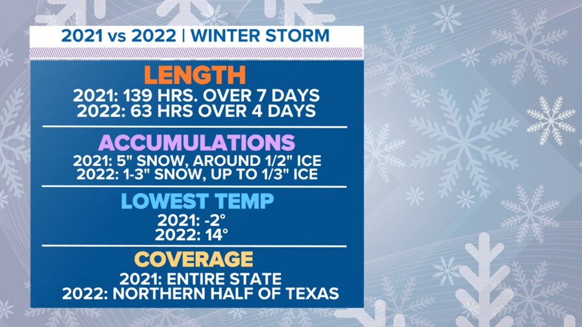
Could there be power outages? It's certainly possible, but this cold snap and winter weather event does not look to affect the entire state like last year, which was one of the major problems in 2021. Power outages may be more localized due to ice. Where that occurs is very hard to predict.
Unfortunately, this looks to be a winter storm that we can get in North Texas from time to time. We've had them before, and we will have them again in the future.