DALLAS — As expected, storms arrived in North Texas on Friday afternoon.
Two lines of rain rode the front wave of a cold front through the Dallas-Fort Worth region, moving west to east. The first line of rain entered the area shortly after 1 p.m.
The second wave hit Downtown Dallas just before 5 p.m. But by 6:30 p.m., the metroplex was clear of storms.
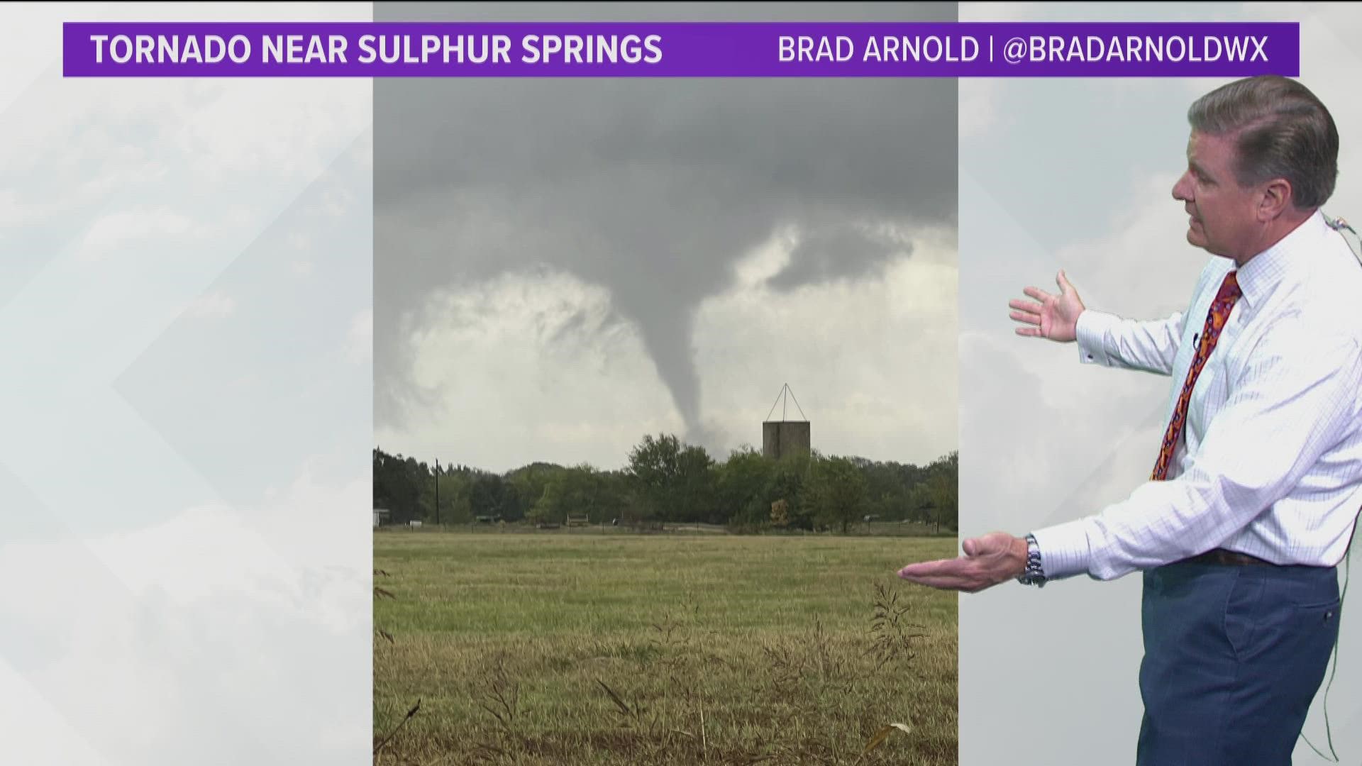
There are no longer any tornado warnings in effect around Dallas-Fort Worth. A tornado is believed to have passed through Sulphur Springs around 6 p.m.
Watch our continuous live coverage of this event here:
Here's the latest forecast, hour-by-hour timeline and how much severe weather we're expecting:
Live Updates
6:53 p.m.
6:34 p.m.
6:31 p.m.
6:21 p.m.
5:58 p.m.
5:44 p.m.
5:39 p.m.
5:37 p.m.
5:22 p.m.
5:20 p.m.
5:10 p.m.
4:52 p.m.
4:47 p.m.
4:43 p.m.
4:36 p.m.
4:27 p.m.
4:20 p.m.
4:18 p.m.
3:57 p.m.
3:55 p.m.
3:52 p.m.
3:47 p.m.
3:41 p.m.
3:30 p.m.
3:03 p.m.
2:50 p.m.
1:50 p.m.
1 p.m: A tornado watch was issued for most of North Texas, including all of the Dallas-Fort Worth Metroplex and most of Northeast Texas.
12 p.m.: A tornado watch is likely for most of North Texas this afternoon.
12 p.m.: Non-severe storms have developed in Denton county. Moderate to heavy rain can be seen in northern Tarrant county. Light rain across the rest of the metroplex. Stronger storms are expected later today.
A stormy Friday
- Timing: Widespread thunderstorm looks most likely Friday afternoon through early Friday night. But some scattered rain looks possible during the morning and afternoon Friday.
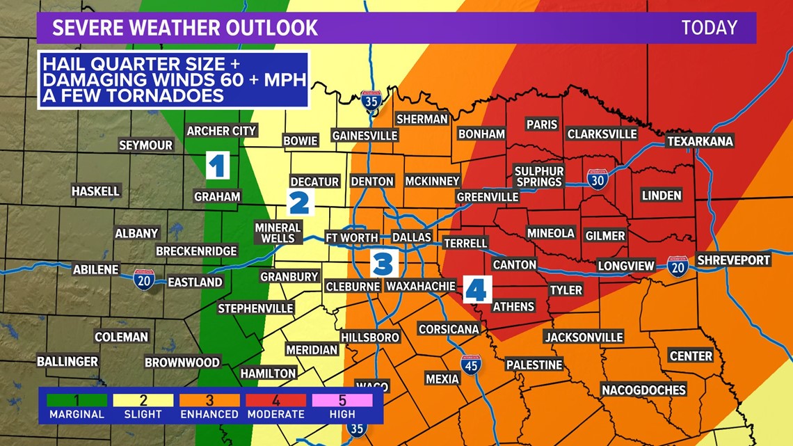
- What: A round of widespread thunderstorms. Some of which could be severe. Main threats look to be damaging winds and quarter size or larger hail. A few tornadoes possible.
- Where: All of North Texas has a chance for widespread storms and potential severe weather. Highest tornado threat will be east of I-35.
Parts of North Texas, to the east of Dallas-Fort Worth, were increased to a Level 4 of 5 risk level, or "moderate" on the Storm Prediction Center's scale, for dangerous storms to develop. Those areas included Kaufman, Hunt and a small portion of Rockwall County. Most of Northeast Texas was placed under this risk level, as well.

Latest timeline forecast:
A cold front was expected to swing through the area from west to east through Friday afternoon, causing the storms.
Storms will form along the front causing the severe weather threat. The main threat will be strong winds and large hail during the afternoon hours. Strong winds will be the main threat during the late evening hours. There is an elevated tornado risk for areas east of I-35.

We cannot rule out the potential for a few, isolated tornadoes. The Storm Prediction Center (SPC) has most of North Texas under an enhanced risk (3/5) for severe weather.
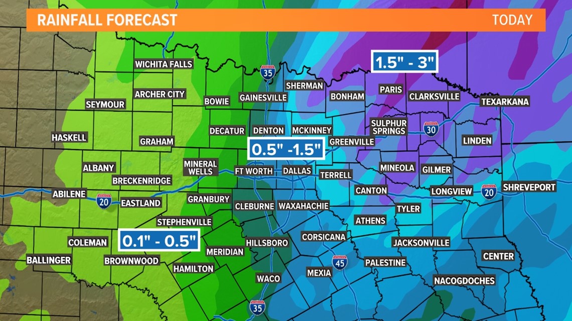
Most rain will move off to the east through the nighttime hours with most places dry by daybreak Saturday. The highest rain accumulations will be north and northeast of the metroplex. A widespread 1/2 to 1 1/2 inches will be possible.

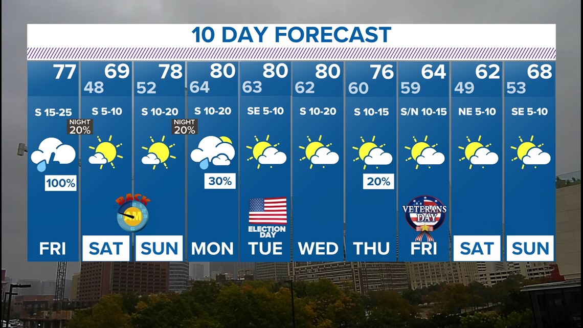
10-day forecast: