
DALLAS — Severe weather was expected to move through North Texas on Friday.
Storms began firing around 1 p.m. for most of North Texas, and they were expected to move through the area into the early evening hours.
Several warnings and watches were in effect for areas in North Texas, but tornadoes broke out in parts of Northeast Texas.
Editor's note: This story is no longer being updated. Please visit wfaa.com for continuing coverage of storm aftermath in North Texas.
6:53 p.m. Multiple homes damaged in tornado near Miller Grove
The Hopkins Office of Emergency Management said a tornado was believed to have touched down near Miller Grove, which is near Sulphur Springs. No fatalities were reported, but multiple homes were damaged.
RELATED: PHOTOS: Tornado touches down near Sulphur Springs, severe weather moves through North Texas
5:30 p.m. Delays continue at Dallas airports
The delays at both Love Field and Dallas Fort Worth International continue, as the ground stops have been extended at both.
- Check your DFW Airport flight status here
- Check your Dallas Love Field flight status here
- Check the latest DFW Airport flight delays and cancellations here (via FlightAware)
- Check the latest Dallas Love Field delays and cancellations here (via FlightAware)
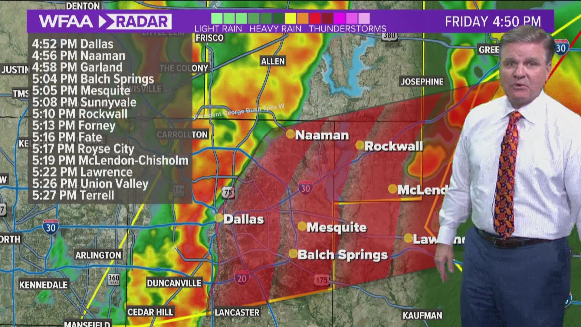
5 p.m. Weather causes traffic headaches in North Texas
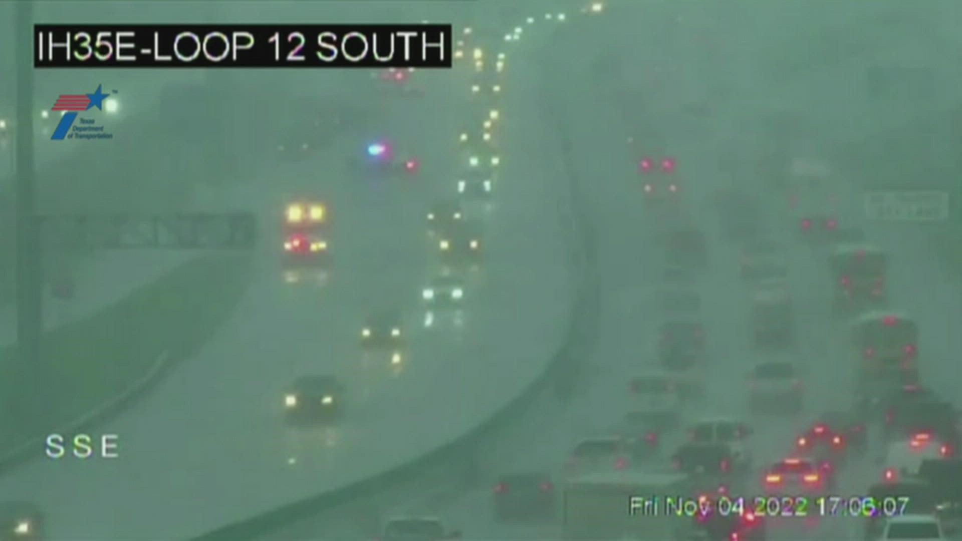
4:45 p.m. Emergency services respond to several accidents
Dallas Fire and Rescue said it has responded to more than 57 accidents since noon.
Fort Worth Police said its responded to 24 major accidents and 15 minor accidents since noon.
4:20 p.m. Officials: Possible tornado touches down in Kaufman County
The Kaufman County Office of Emergency Management said a possible tornado has touched down near the area of Murphy Lake and FM 148.
The possible tornado was rain-wrapped, officials said.
No reports of damage have been made, Kaufman County OEM said.
No other details were released.
4 p.m. Thousands without power amid storms
Oncor is reporting thousands of power outages in North Texas.
3:52 p.m. Ennis ISD campuses reopens after sheltering in place
Due to weather, Ennis ISD said all campuses were sheltering in place. The shelter-in-place was lifted Friday afternoon.
3 p.m. Tornado Warning issued for several North Texas counties
A tornado warning has been issued for Ellis, Hill and Navarro counties until 3:30 p.m.
1:45 p.m. School districts release students early due to weather
Corsicana ISD said it released students early Friday due to inclement weather. Middle and high school students were released at 1 p.m. and elementary school students were released at 1:30 p.m.
Sulphur Springs ISD said students were released from school at 1:30 p.m. due to weather.
1:14 p.m. Richardson ISD delays games due to weather
Richardson ISD said the Highland Park vs. Pearce varsity football game was being moved back one hour to 8 p.m. due to weather.
The Berkner vs. MacArthur varsity football game is also being moved back one hour to 8 p.m.
1 p.m. Tornado Watch issued for several North Texas counties
A tornado watch has been issued for several North Texas counties until 8 p.m.
Earlier:
As the weather moves in, you'll probably want to check your flight status, if you're flying out of (or into) Dallas-Fort Worth International Airport or Dallas Love Field.
Here are all the links you need:
- Check your DFW Airport flight status here
- Check your Dallas Love Field flight status here
- Check the latest DFW Airport flight delays and cancellations here (via FlightAware)
- Check the latest Dallas Love Field delays and cancellations here (via FlightAware)
Stormy Friday
- Timing: Widespread thunderstorm looks most likely Friday afternoon through early Friday night. But some scattered rain looks possible during the morning and afternoon Friday.
- What: A round of widespread thunderstorms. Some of which could be severe. Main threats look to be damaging winds and quarter size or larger hail. A few tornadoes possible.
- Where: All of North Texas has a chance for widespread storms and potential severe weather. Highest tornado threat will be east of I-35.
Most rain will move off to the east through the nighttime hours with most places dry by daybreak Saturday. The highest rain accumulations will be north and northeast of the metroplex. A widespread 1/2 to 1 1/2 inches will be possible.