
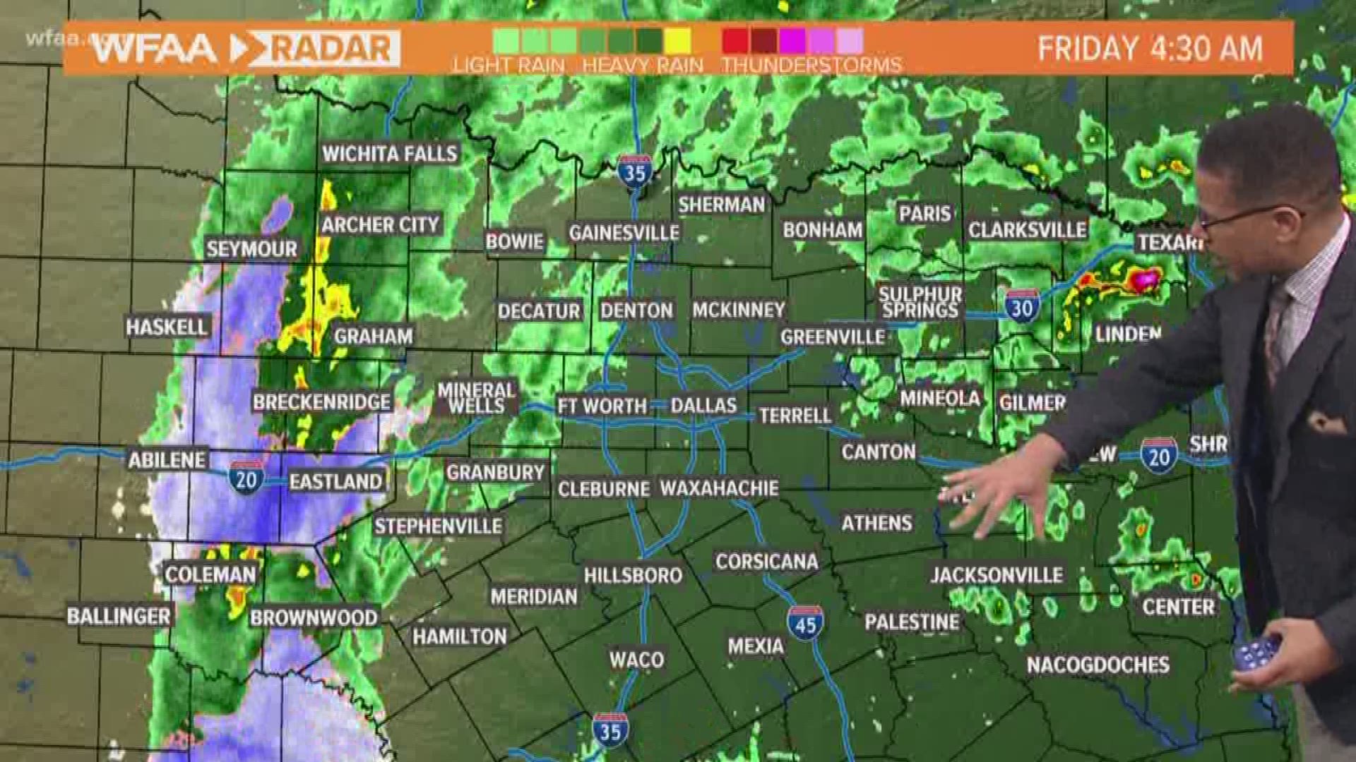
Hold on to your steering wheel! Drivers in DFW should expect a messy commute Friday morning as more rain is expected. Making matters more complicated, a Wind Advisory is in effect meaning gusts up to 40 mph are possible.
A winter weather advisory that was in effect for much of North Texas was canceled for DFW early Friday morning but remained in effect for Stephens, Eastland and other far western counties.
We'll be providing the latest weather updates Friday morning.
• Be sure to download the WFAA app to track latest radar near you and the updated forecasts.
• Check Weather Alerts here.
• LATEST Traffic Map and conditions
LATEST UPDATES:
8 a.m. As the wintry mix dissipates mid-morning, we'll be left with passing showers through mid-afternoon. Luckily for North Texans, Friday night plans should be mostly dry, even if a little chilly.
6:31 a.m. A wind advisory remains in effect in North Texas until noon. Winds stay gusty with gusts of 35 to 45 mph possible at times.
6 a.m. Before our weather system moves on, lingering showers and gusty winds will continue through the morning hours. Yes, just rain for most. Far western parts of North Texas (Stephens and Eastland counties) will continue to see a rain/snow mix through mid-morning. A Winter Weather Advisory is still in effect for those locations. Significant snow is not likely, and it likely won't even accumulate. However, there still could be some slick spots on bridges and overpasses through mid-morning. -- Meteorologist Kyle Roberts
5:30 a.m. Temperatures were well above freezing and expected to be in the 40s throughout the day Friday. Still, roads could be slick – and possibly slushy where some snow had fallen in our western counties – and wind gusts topped 20 mph in several parts of North Texas just after 5 a.m.
There were no reports of any snow accumulating or even sticking to the warm North Texas ground.
3:45 a.m. A winter weather advisory was canceled in DFW but remained in effect for Stephens, Eastland and other far western counties.
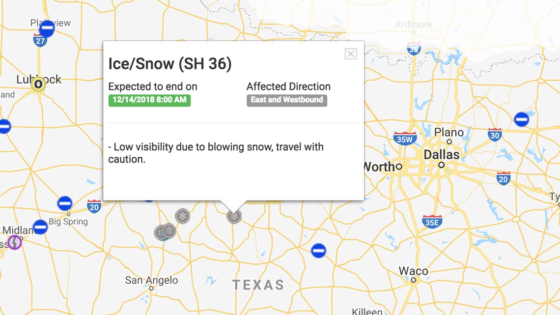
3 a.m. Reports of Ice/snow on highways south of Abilene including US 277 and SH 36. Check TxDOT road conditions map.
2 a.m. Winter weather remains in far west North Texas. Up to 6 inches of snow was reported on the ground in the Sweetwater area causing trouble on nearby roadways including I-20 and Hwy 70 on Thursday. The mayor of Tuscola and his wife were killed in an accident on Hwy 83, according to KTXS.
10 p.m. Strong winds are moving in tonight and will around much of Friday. Gusts are already exceeding 40 mph in parts of western North Texas.
9 p.m. Where are the strong winds? The center of the storm system is taking its sweet time moving east. It'll press forward over the next few hours. The strong gusts west of DFW will move in.
7:30 p.m. Wintry mix is possible mainly west of DFW on Friday morning. Focus on the beautiful weather this weekend!
5:30 p.m. Be prepared for delays if you're flying out of either DFW Airport of Dallas Love Field. Delays at DFW were at about an hour behind, but it's back to normal. That's expected to change, so check with your airline.
Will I see snow? Areas under the Winter Weather Advisory have the best chance for accumulating snow up to 3". Outside of that, we expect a very light to no accumulation in and around the DFW area. However, this is a tricky forecast so stay tuned for updates.
Heading into Thursday night, showers and storms will increase across North Texas as winds pick up behind the front as well. Just rain or even some storms for the DFW area for the the rest of Thursday. In far western part of North Texas, a rain to snow transition is possible this evening into tonight.WIND:This will affect 100% of North Texas mainly this evening and overnight. Winds will increase out of the north starting this afternoon, but really increasing this evening into tonight. Almost all of North Texas is under a Wind Advisory for this reason. Sustained winds of 25 mph to 35 mph with gusts approaching 50 mph at times are possible. Wind gusts of 50+ mph are possible across western North Texas. This means any loose outdoor items or Christmas decorations will be susceptible to be blown around or blown away. Make sure they are secured or moved indoors! Small tree limbs make get knocked down as well and some power outages are possible. Winds stay very gusty into Friday morning, but will decrease during the day on Friday. Friday will still be plenty breezy, but not nearly as strong as the winds this evening and overnight.%INLINE%WINTRY WEATHER:This will NOT affect 100% of North Texas. In fact, there's a fairly small area that has a chance for snow accumulation to cause problems. This is the area under the Winter Weather Advisory, which is far western parts of North Texas, and does NOT include the DFW area. Rain will spread across North Texas this afternoon into this evening, and in those locations a rain/snow mix is possible or a transition to just snow by this evening into tonight. That snow may come down heavy enough to accumulate on grassy and elevated surfaces as well some lesser traveled roadways. Accumulations of up to 3 inches are possible, although there could be some isolated higher amounts. Travel problems are certainly possible in the Winter Weather Advisory area this evening, tonight, and into Friday morning.Now for the DFW area. Rain is likely this evening and overnight. Some of that rain could transition into a rain/snow mix at times. However, even though it will be cold it does not look cold enough for anything to stick, especially on roadways. Simply, if you see snow mixed with rain, enjoy it! But any problems look unlikely. What does look likely is that roadways will be wet Friday morning, not snowy or icy, but wet. So a slow and messy Friday morning commute is in the forecast.STORMS:There is also a chance of thunderstorms across far eastern North Texas this afternoon into evening. Most t-storms will be confined to East Texas and the Arklatex, but some storms will be possible across far eastern parts of North Texas. A few could be strong to severe as well. Large hail and damaging winds will be the main threat with any severe storms. The tornado threat is low, but not zero.WEEKEND:
Any precipitation moves out of North Texas heading into Friday evening. By the weekend sunshine returns. In fact, the weekend is looking rather nice! Sunshine both days with highs in the upper 50s to low 60s.