DALLAS — Ready for week to get started, North Texas? Here's the weather coming our way as things kick off.
LIVE UPDATES:
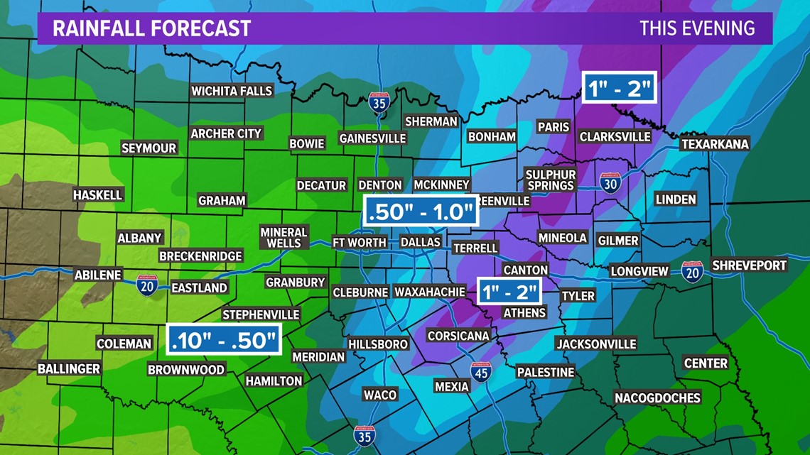
10:15 pm:
10:00 pm: The threat for severe weather has significantly lowered. The main line of showers and thunderstorms has pushed east of the metroplex. Heavy rain, lightning and strong winds continues for east and southeast Texas through the overnight hours.

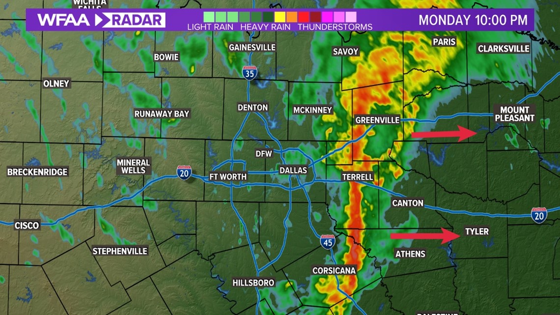
9:40 pm: The line of showers and storms continues to move east containing heavy rainfall and gusty winds. Light, scattered showers are lingering behind the line. Threat for severe weather is low.
9:00 pm: Just about everyone in Dallas county is experiencing rain. Heaviest rain is located right in the middle of the county. Severe Thunderstorm Watch has expired.
7:35 pm: A tornado watch has been issued for Central Texas. DFW is not included in this watch.
7:30 pm: A strong storm is now over Forth Worth in Tarrant co moving NE at 40 mph. This storm could produce 50 mph winds and small hail along with heavy rainfall.
6:15 pm: Scattered showers and storms are popping up ahead of the main line of thunderstorms. Currently no severe storm warnings are in place for the metroplex. One severe storm warning is in place along the line south of I-20/Eastland.
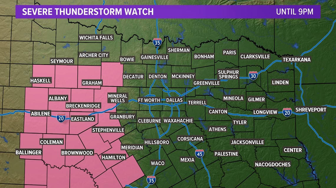
4:30 pm: Severe Thunderstorm Watch has been issued west of DFW until 9pm. The area under the watch has been clear for hours allowing for air to become unstable. Storms that move into/develop in this area have the potential to turn severe (60+ mph gusts, hail, iso. tornado)

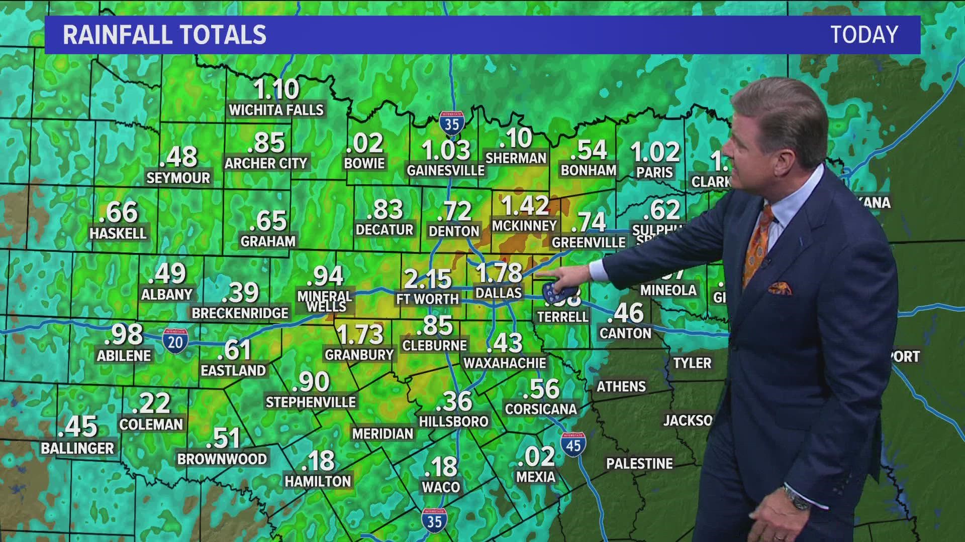
3:30 pm: Light to moderate rainfall continues. This is mainly south of DFW, Dallas county, Collin county and east. Tarrant/Denton counties and west have a bit of a break. Generally, 1/2 to 1" of rain has been recorded across the metroplex.
3:00 pm: Slight (2/5) risk for severe weather still exists across most of NTX. Between now & 7pm, light to moderate rain. After 7pm, front comes in from west to east along with storms. This is where we could see strong winds, hail and a brief, isolated tornado.
2:00 pm: Light to moderate rain continues. A few locations may see a quick burst of heavier rain. Winds are gusting up to 30 mph. Temps are in the mid-60s. Expect more storms late this afternoon and evening. Severe threat is higher east and south of DFW.
1:00 pm: Light to moderate rain continues. No warnings. Gusty 25 - 35 mph winds with the stronger storms. More activity expected this afternoon, especially east and south of the metroplex.
12:35 pm: Non-severe showers and storms continue to push east. Moderate to heavy rainfall along the leading lines. Gusty winds near 25 to 35 mph possible. Otherwise, light rain is spotted across the rest of North Texas.
More storms on the way this afternoon.
12:00 pm: Initial line of storms continues to move east across the eastern half of the metroplex. Meanwhile a new cluster of storms west will be the next area to watch. At the moment, no warnings are in place.
11:30 am: Line of non-severe storms continues to moves east across the metroplex. Some strong winds of 25 to 45 mph winds along with heavy rain are possible.
11:10 am: Long line of showers and thunderstorms continues to moves east across the metroplex. Strong winds (25 to 40 mph) and heavy rain are seen pushing through DFW with this line. At the moment - NO SEVERE WARNINGS in place. Watch for areas of flooding.
Changes come early this week
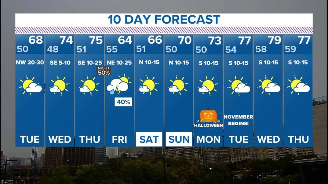
Our early week system brings rain and some strong storms with cooler, more fall-like temperatures.
A line of thunderstorms formed along a cold front to our west. It'll progress across North Texas through the evening hours.
The line of storms made it into our western counties during the evening hours.
While the overall severe threat was on lower end, there is a chance for storms within that line to have strong to damaging wind gusts and hail up to the size of quarters.
The tornado threat is not completely zero -- but it is very low, and mainly for the areas east and southeast of Dallas-Fort Worth.
Lingering showers or storms are also possible Monday evening into Tuesday morning, but the overall coverage will be lower.
By Tuesday morning, most rain will have moved out of the area, aside from some lingering rain in northeastern North Texas.
When it is all done, around one inch of rain looks likely for most of the area, with higher totals east and northeast of Dallas-Fort Worth and lower totals to the west and southwest.

Nice weather!
The forecast this week looks much more October-like than what we've seen recently! Cooler with multiple rain chances. Highs during the workweek will be in the 70s and 60s, with another round of rain possible on Friday.